
Some of the earliest jigsaw puzzles on record are those made from dissected maps intended for use in teaching geography to children. British jigsaw puzzle makers offered such products as early as the 1760s, while in France and the Netherlands examples of jigsaw puzzle maps appear in the late1770s. Similar German and Austrian made map jigsaw puzzles appear about 1820. North American manufacture of map jigsaw puzzles first began about 1850. Contemporary commercial jigsaw puzzle makers continue to offer maps for sale to the public for their entertainment, education, and amusement. Here are some examples from the collection.
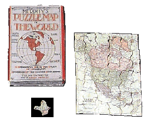
This jigsaw puzzle was donated to the Museum in 1983. The donor indicated that it was originally purchased by the family sometime around 1910-15.
When the puzzle is assembled it is 17.7cm long x 12.7cm wide. The pieces are non-interlocking and have interesting shapes. Note: the one illustrated that is shaped like a bird. The box is 15.7cm x 10.7cm x 2cm and indicates that the puzzle was made by Murphy Company, Cleveland, Ohio.
In trying to determine the age of the puzzle (since it does not have a copyright date on the box), it is noted that the map includes the political identification Dominion of Canada, rather than just "Canada". The use of this identification occurred in 1867 with the passage of the British North America Act.
 This jigsaw puzzle was purchased by the Museum in 1983. When the 208 pieces are assembled, this puzzle is 35.6cm long x 41.9cm wide. Pieces are about 3.5cm x 2.8cm, and are made of printed colored paper glued to cardboard. Each Canadian Province is in a different color with its name, capital city name, and a list of natural resources in black print. On the lower left side is a bilingual (French and English) printed legend of map symbols.The reverse side of the puzzle is plain.
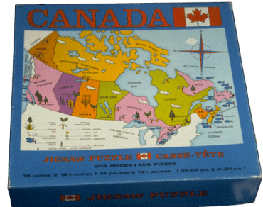
The box is 25.2cm long x 26.2cm wide x 5.2cm high. In addition to the picture of the puzzle on the box top, the manufacturer's name is printed on the side. The puzzle was produced by the Regal Stationery Company Limited, Toronto. It is thought to have been made in the 1960s.
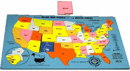
This puzzle was donated to the Museum in 1982. The puzzle is made of plywood with some metal fittings. The top of the board is a frame painted blue, with a cut-out area (painted dark blue and white) for placing each of the puzzle pieces. The underside is painted pink. The frame is 30cm long x 39.2cm wide x 1cm thick. A cut-out area in the frame is an outline map of the 48 continental US States. On the lower left side of the frame is a circular cut-out area for Alaska and Hawaii. On the right side of the frame is a list of abbreviations, instructions, distance scale, compass, etc.
There are 50 pieces, each about .5cm thick. Pieces are made of plywood, and painted a different color on top and pink on the other side. Each piece is cut like an outline map of a US State, and the name of each State is printed in black on each piece. The pieces range in size from 1.2cm x 1cm to 12cm x 11cm. The piece taken out and placed at the top is the state of "New Mexico". The puzzle was manufactured by Playskool, Inc. sometime in the early 1970s.
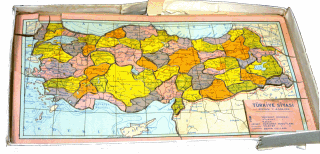
This puzzle was donated to the Museum in 1982. A family member of the donor indicated that the puzzle was bought in Turkey sometime in the 1960s. All of the printing on the puzzle is in the Turkish language, thus it might be assumed that this was a puzzle manufactured for the Turkish market in Turkey, but it may have been manufactured elsewhere and marketed in Turkey. In attempting to date the manufacture of the puzzle, it was noted that while the puzzle is primarily a map of the Turkish state, it includes the island of Cyprus and pictures a British flag on this island. Britain ruled Cyprus from 1878 until 1960.
While the box in which the puzzle resides is made of cardboard, the puzzle pieces themselves are made of a .4cm wood veneer covered with paper. This is a two sided puzzle. Each side is a mirror image of the map of Turkey with different information printed on the pieces.The box is 22.1cm x 41cm x 2.3cm, and the puzzle itself is 20.9cm x 39.9cm x .4cm. Although not shown in this photograph, the box lid features a picture of one of the maps of Turkey that can be made with the puzzle, and the inside of the lid illustrates the other map which can be constructed from the pieces. The words Turkiye Siyasi with other commentary are printed on the lower right corner on the picture on the top of the lid, and the words Turkiye Komsu Memleketler are printed above the illustration on the inside of the lid.
One side of the puzzle is a map of Turkey divided into political jurisdictions, marked with provinces, cities, bordering countries and their cities. Pieces are cut along political boundary lines. Each province is printed in a different color. The other side of the puzzle is the same map, however the printed information on this side indicates agricultural and other products from each political jurisdiction, as well as other information.
Last update April 3, 2010