
Acquired by the Museum in 1982, little is know about this map game. Only the board was available - there were no minor pieces or a container. According to the source from which the game was purchased, it was typical of the style of a number of early 19th century commercial game boards made in England.
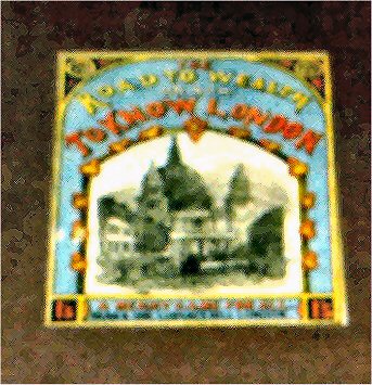
The label with the name of the game is quite colorful and includes an illustration of Saint Paul’s Cathedral in central London built by British architect Sir Christopher Wren. The Cathedral is a universally known landmark of the city. Wren's building was completed in 1710. A large dome rises 365 ft over the building's central crossing point. The main entrance at the west front is flanked by two towers which can also be seen in the drawing.
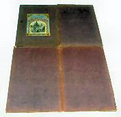
As can be seen from the photograph (on the right) of the back of the game board, the label with the name of the game appears on this side of the board. The board folds in four either for storage in that manner, or because it is placed in a box. The back of the board is covered in a fabric like paper and is about 2cm thick. There weren't any instructions with the game (other than the information printed on the board), nor were there any minor pieces included, so it not known how the game is played. Since there was neither a "spinner" nor dice with the game, we do not know how players progressed around the board.
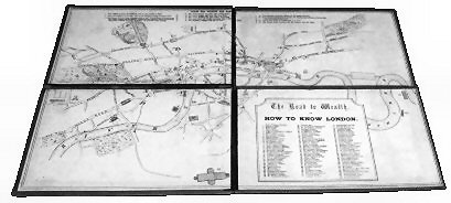
The front of the game board (as seen in the photo at the left) appears to be a stylized line drawing of the map of central London. The Thames River can be seen running the length of the board from the lower left side to the center right side of the board. Various park areas are sketched on the board. Throughout the board are rectangular symbols which appear to be the geographic areas where some of London's famous historic buildings and monuments are situated. The three column list on the lower right quadrant of the board is a list of such buildings and monuments as well as streets.

At the bottom right corner of the upper left quadrant of the game board, one can see a "bend" of the Thames River. Prior to the 21st century, this area of the River was considered by most "Londoners" to be the geographic center of the city.
A contemporary partial map of London (above) is offered for comparison purposes. The game board map appears to be a somewhat accurate copy of the geographic features of the city of London.
It has been suggested that this is just a game that might have had only recreational purposes. However, the game may have had an additional use in that London taxi drivers had to pass detailed examinations concerning their knowledge of the city of London. Perhaps this map game was used as a teaching tool for that purpose in the past.
Last update March 24, 2010